Mapping Arctic Infrastructures: From the Global to the Local
By Alexis Sancho Reinoso and Timothy Heleniak
In this blog post, we explain how InfraNorth plans to contribute to the long tradition of mapping the Arctic regions by providing local-scale portraits on how local communities engage with existing and planned transport infrastructures in times of environmental, economic and geopolitical concerns in the whole region.
A matter of perspective
Even when current digital online tools such as Google Earth have turned our perspectives and understanding of what a map is upside down, most of us (at least Westerners living in the Northern Hemisphere) still have a standard map in their minds showing a section of the Earth where the North arrow always points to the upper part. The example par excellence is the Mercator map, where Earth surface distorts as one moves away from the Equator. In this map, Greenland’s area (2.2 Mkm²) surpasses the one of Africa (more than 30 Mkm²) and the poles are represented by lines instead of points.
Looking for infrastructure
Being crucial for human communities, infrastructure has a strategic character and is therefore continuously being inventoried and mapped, also in higher latitudes. Some representative examples are the Arctic Infrastructure Inventory (undertaken by The Wilson Centre) and The Arctic Spatial Data Infrastructure (SDI) Geoportal, a joint effort of National Mapping Agencies from all Arctic states. As any other spatial-related feature, mapping infrastructures requires using techniques such as remote sensing. This allows getting information from satellite imagery to identify spatial features. In regions such as the Arctic, remote sensing plays an even more relevant role, since on-site fieldwork (which is, indeed, key to verify what is obtained from imagery) is usually much more difficult (and expensive) than in lower latitudes. A recently published paper shows the current progress in this respect. In the Arctic, infrastructure often lies in surfaces that are dramatically changing. Permafrost and sea ice enable the operationality of every object and they might be considered as “elemental infrastructure”. Therefore, mapping permafrost can be considered as a critical contribution to better know the state of Arctic infrastructure.
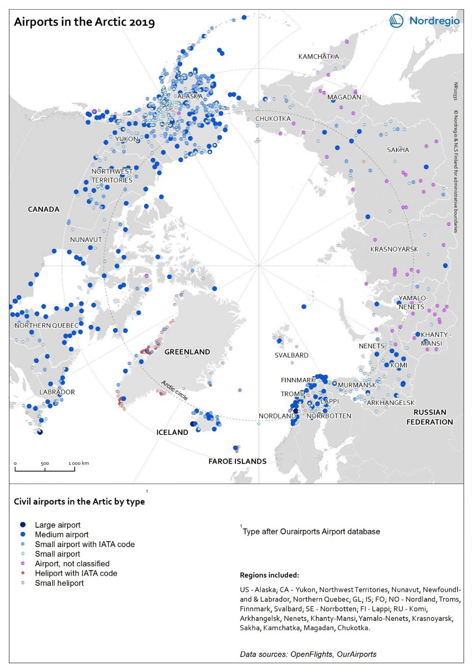
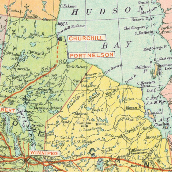
Remote sensing is by no means the only way to obtain information for mapping infrastructure. Surveying them also requires using various national and international databases. This is everything but a straightforward endeavor, given the quite different physical settings, infrastructure needs and projects, and statistical systems. Airports are a good example as they have been crucial for polar exploration and are often the sole means of accessing many remote Arctic settlements. Locating and defining airports in the Arctic was a challenge as discovered when compiling the Atlas of population, society and economy in the Arctic (see attached map). There are only a few large airports in the Arctic with regular connections outside the Arctic and there are many smaller airports in the Arctic with irregular connections that lack international classification.
Mapping transport infrastructure in arctic communities
InfraNorth operates at multiple scales. Global and regional maps of infrastructure provide context for the local scale, which is the focus of the project. InfraNorth addresses the question concerning the ways local residents engage with the existing and projected transport-related infrastructure in a series of selected case studies across the Arctic. We therefore deal with both hard facts from statistics, but also non-tangible issues, such as satisfaction, expectations, or promises, and we will produce maps (mainly at local scale) to connect them to actual infrastructure objects. Using qualitative GIS (Geographical Information Systems) will enable us to represent the spatial dimension of the combined outcome from statistical data and fieldwork ethnography in form of on-site observations, interviews, questionnaire surveys, and locally organised workshops.
InfraNorth will also take advantage of maps as a powerful outreach tool. Cartographic storytelling is a way of conveying memories and stories of lifeways that are of concern to people in their everyday life. One example in this respect is the research project Configurations of Remoteness” (CoRe) about entanglements of people and railway infrastructure in East Siberia. In the context of this project, the cartographic storytelling portal “Life of BAM” explored possibilities of conveying contents using dynamic and interactive digital supports.

Please login to post a comment...